BatchGeo is an intuitive online mapping tool that effortlessly transforms spreadsheets, CSV files, or simple lists into comprehensive, interactive maps. Since 2006, BatchGeo has empowered businesses, non-profits, and individuals with a simple yet powerful solution to visualize location data, turning raw addresses into strategic insights.
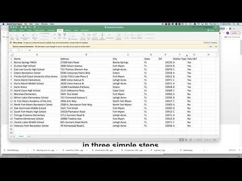
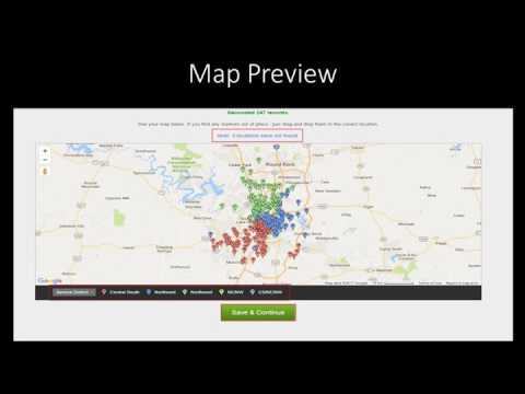
Within the Geospatial Analytics category, BatchGeo distinguishes itself by focusing on usability and functionality. The platform streamlines the process of mapping data from sources like Excel or Google Spreadsheets. Simply copy and paste your list, and BatchGeo automatically geocodes addresses, placing each point accurately on an interactive map. This approach minimizes manual entry errors and speeds up the transition from data to visual insight.
Key Features
- Easy Data Import: Quickly input your data directly from spreadsheets, enabling fast and accurate map creation without specialized GIS expertise.
- Customizable Maps: Enhance your maps with color coding, labels, markers, and even heat maps to visually differentiate between data groups and highlight important trends.
- Optimized Routing: Plan efficient routes for up to 23 points at a time, an invaluable tool for sales teams and service technicians aiming to minimize travel time and costs.
- Advanced Data Visualization: With capabilities to overlay multiple data sets, perform spatial analysis, and generate custom reports, BatchGeo helps you extract actionable insights from location data.
Flexibility is another strong suit of BatchGeo. You can secure your maps with password protection or share them for public viewing, making it easier to collaborate with colleagues or provide customers with interactive store locators. The platform’s interface remains uncluttered despite its robust features, ensuring that users can quickly learn, adapt, and deploy their maps for a variety of purposes without a steep learning curve.
Why Choose BatchGeo?
BatchGeo simplifies the complex process of geocoding by integrating with familiar spreadsheet applications. Its user-centric design ensures that you spend less time wrestling with software and more time leveraging the insights hidden within your data. Whether you are engaged in market analysis, sales territory planning, or community outreach, BatchGeo provides a fast, efficient, and versatile mapping solution that adapts to your needs.
Exclusive Deals
Take advantage of special offers by visiting the BatchGeo Deals page.
Alternative Option
Embrace BatchGeo to unlock the full potential of your data. Its combination of ease-of-use, powerful analytics, and flexible sharing options makes it a must-have tool in today’s data-driven environment.