Top software categories
Business Intelligence, Data Integration and SEO Analytics.
Fintech and Banking and Financial Management.
Project Management, Time Tracking and Collaboration Tools.
AI Tools, Video Editing, AI Writing Assistant and Audio Editing Software.
CRM, Call Center Software and Customer Feedback Software.
Web Development & Design, Software Testing Tools and API Tools.
Medical Practice Management and Digital Health Solutions.
HR Management, Recruiting and Payroll Software.
Marketing Automation, Email Marketing and SMS Marketing.
Cybersecurity, Data Protection and Email Security.
Create Your Product Profile
Buyers and AI assistants check what others say about your product long before they talk to sales. Own that reputation and turn it into pipeline.
Want help? we set it up with you, Book a call
Top service categories
Oracle Cloud, AWS and Azure partners for migration, DevOps and managed cloud.
Webflow, Framer and Shopify agencies, and UX/UI studios.
Oracle, NetSuite, SAP and Microsoft Dynamics implementation partners.
Workday and BambooHR implementers, payroll and HR outsourcing.
AI implementation, data engineering and BI teams.
Fractional CFOs, bookkeeping and QuickBooks or Xero advisors.
Salesforce, HubSpot and Zoho partners for setup, migration and RevOps.
Branding, design and video production studios.
Cybersecurity, SOC 2 and ISO 27001 consultants.
Zapier, Make and n8n experts who build and maintain workflows.
SEO, paid ads, content and marketing automation agencies.
Custom software, mobile apps, QA and low-code builds.

Create Your Company Profile
Show up as the verified expert on the products you work with, and get calls booked by teams ready to buy.
Want help? we set it up with you, Book a call

Claim this profile to manage it.
BatchGeo is an intuitive online mapping tool that effortlessly transforms spreadsheets, CSV files, or simple lists into comprehensive, interactive maps. Since 2006, BatchGeo has empowered businesses, non-profits, and individuals with a simple yet powerful solution to visualize location data, turning raw addresses into strategic insights.
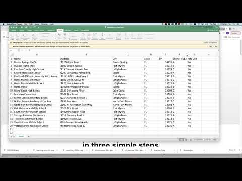
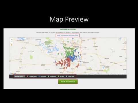
Within the Geospatial Analytics category, BatchGeo distinguishes itself by focusing on usability and functionality. The platform streamlines the process of mapping data from sources like Excel or Google Spreadsheets. Simply copy and paste your list, and BatchGeo automatically geocodes addresses, placing each point accurately on an interactive map. This approach minimizes manual entry errors and speeds up the transition from data to visual insight.
Key Features
Flexibility is another strong suit of BatchGeo. You can secure your maps with password protection or share them for public viewing, making it easier to collaborate with colleagues or provide customers with interactive store locators. The platform’s interface remains uncluttered despite its robust features, ensuring that users can quickly learn, adapt, and deploy their maps for a variety of purposes without a steep learning curve.
Why Choose BatchGeo?
BatchGeo simplifies the complex process of geocoding by integrating with familiar spreadsheet applications. Its user-centric design ensures that you spend less time wrestling with software and more time leveraging the insights hidden within your data. Whether you are engaged in market analysis, sales territory planning, or community outreach, BatchGeo provides a fast, efficient, and versatile mapping solution that adapts to your needs.
Exclusive Deals
Take advantage of special offers by visiting the BatchGeo Deals page.
Alternative Option
Embrace BatchGeo to unlock the full potential of your data. Its combination of ease-of-use, powerful analytics, and flexible sharing options makes it a must-have tool in today’s data-driven environment.
BatchGeo is an intuitive online mapping tool that effortlessly transforms spreadsheets, CSV files, or simple lists into comprehensive, interactive maps. Since 2006, BatchGeo has empowered businesses, non-profits, and individuals with a simple yet powerful solution to visualize location data, turning raw addresses into strategic insights.
Within the Geospatial Analytics category, BatchGeo distinguishes itself by focusing on usability and functionality. The platform streamlines the process of mapping data from sources like Excel or Google Spreadsheets. Simply copy and paste your list, and BatchGeo automatically geocodes addresses, placing each point accurately on an interactive map. This approach minimizes manual entry errors and speeds up the transition from data to visual insight.
Key Features
Flexibility is another strong suit of BatchGeo. You can secure your maps with password protection or share them for public viewing, making it easier to collaborate with colleagues or provide customers with interactive store locators. The platform’s interface remains uncluttered despite its robust features, ensuring that users can quickly learn, adapt, and deploy their maps for a variety of purposes without a steep learning curve.
Why Choose BatchGeo?
BatchGeo simplifies the complex process of geocoding by integrating with familiar spreadsheet applications. Its user-centric design ensures that you spend less time wrestling with software and more time leveraging the insights hidden within your data. Whether you are engaged in market analysis, sales territory planning, or community outreach, BatchGeo provides a fast, efficient, and versatile mapping solution that adapts to your needs.
Exclusive Deals
Take advantage of special offers by visiting the BatchGeo Deals page.
Alternative Option
Embrace BatchGeo to unlock the full potential of your data. Its combination of ease-of-use, powerful analytics, and flexible sharing options makes it a must-have tool in today’s data-driven environment.
Learn what people say about BatchGeo
Be the first to share your experience and help others in the community.
BatchGeo is an intuitive online mapping tool that effortlessly transforms spreadsheets, CSV files, or simple lists into comprehensive, interactive maps. Since 2006, BatchGeo has empowered businesses, non-profits, and individuals with a simple yet powerful solution to visualize location data, turning raw addresses into strategic insights.
Within the Geospatial Analytics category, BatchGeo distinguishes itself by focusing on usability and functionality. The platform streamlines the process of mapping data from sources like Excel or Google Spreadsheets. Simply copy and paste your list, and BatchGeo automatically geocodes addresses, placing each point accurately on an interactive map. This approach minimizes manual entry errors and speeds up the transition from data to visual insight.
Key Features
Flexibility is another strong suit of BatchGeo. You can secure your maps with password protection or share them for public viewing, making it easier to collaborate with colleagues or provide customers with interactive store locators. The platform’s interface remains uncluttered despite its robust features, ensuring that users can quickly learn, adapt, and deploy their maps for a variety of purposes without a steep learning curve.
Why Choose BatchGeo?
BatchGeo simplifies the complex process of geocoding by integrating with familiar spreadsheet applications. Its user-centric design ensures that you spend less time wrestling with software and more time leveraging the insights hidden within your data. Whether you are engaged in market analysis, sales territory planning, or community outreach, BatchGeo provides a fast, efficient, and versatile mapping solution that adapts to your needs.
Exclusive Deals
Take advantage of special offers by visiting the BatchGeo Deals page.
Alternative Option
Embrace BatchGeo to unlock the full potential of your data. Its combination of ease-of-use, powerful analytics, and flexible sharing options makes it a must-have tool in today’s data-driven environment.
To cancel a BatchGeo subscription, access the "Subscription" section in the Account Admin menu. Follow the prompts to complete cancellation. Maps remain accessible after cancellation.
Want to list your product on Subscribed.fyi? Create a profile to reach more buyers.